Notice: Constant QUADMENU_DOMAIN already defined in /home/devicigi/cigidenweb.ing.uc.cl/wp-content/plugins/quadmenu/quadmenu.php on line 41

Notice: Accessing static property WPB_YourChannel::$yrc_permission as non static in /home/devicigi/cigidenweb.ing.uc.cl/wp-content/plugins/yourchannel/YourChannel.php on line 53
The challenge of geophysics: Uncertainty in the study of earthquakes in Chile | CIGIDEN
  • Anuncios
  • Contacto
CIGIDEN
  • NOSOTROS
    • El centro
    • Equipo
    • Investigadores
      • Investigadores
      • Personal de apoyo
      • Postdoctorados
    • Guía de Expertos 2020
  • INVESTIGACIÓN
    • Líneas de Investigación
      • L1. Amenazas por procesos de tierra sólida
      • L2. Amenazas por procesos de aguas superficiales
      • L3. Riesgo y resiliencia en sistemas complejos y redes
      • L4. Cultura del desastre y gobernanza del riesgo
      • L5. Evaluación socioeconómica para la mitigación del riesgo de infraestructura crítica
      • L6. Gobernanza Ciudadana
    • Proyectos
  • DIVULGACIÓN
    • Noticias
    • Cigiden en los medios
    • Columnas
    • Videos
    • Exposiciones
      • Chile territorio en movimiento
      • Desde el cielo
      • Desartes
  • PUBLICACIONES
    • Papers
    • Libros y manuales
    • Policy Papers
  • DESARTES
  • AGENDA
    • Seminarios y congresos
    • Conversatorios
    • Charlas y Talleres
No hay resultado
Ver todos los resultados
CIGIDEN
No hay resultado
Ver todos los resultados
Inicio Dissemination

The challenge of geophysics: Uncertainty in the study of earthquakes in Chile

CIGIDEN researcher Roberto Benavente, currently assistant professor at the Universidad Católica de la Santísima Concepción (UCSC), presented his research on rapid seismic source modelling during emergencies (modelado rápido de la fuente sísmica en emergencia), aimed at conducting research using Bayesian inference, a methodology that allows capturing, calculating or measuring the uncertainty of seismic sources and tsunamis.

CIGIDEN Por CIGIDEN
16 diciembre, 2020
en Dissemination, L2. Surface water processes and associated hazards, News
0
Reducir los desastres es aprender de nuestro pasado y de nuestro entorno hoy
0
Compartido
0
vistas
Share on FacebookShare on TwitterShare on Linkedin

CIGIDEN researcher Roberto Benavente, currently assistant professor at the Universidad Católica de la Santísima Concepción (UCSC), presented his research on rapid seismic source modelling during emergencies (modelado rápido de la fuente sísmica en emergencia), aimed at conducting research using Bayesian inference, a methodology that allows capturing, calculating or measuring the uncertainty of seismic sources and tsunamis.

Science also involves uncertainty. This disturbing statement – since scientific answers are always expected to be accurate- is a reality studied by many disciplines developing sophisticated and complex numerical systems.

An area of mathematics known as “inverse problem” is used to connect the information contained in data with physical models explaining them. This study facilitated the design of complex models required to create, for example, sophisticated telescopic lenses capable of adapting themselves to the atmospheric effects for the observation of the universe, and also to obtain images of our body through computerized tomography or TACs. When available data are only able to provide limited information about the phenomenon being studied, calculating the associated uncertainties becomes critical for the proper interpretation thereof. This scenario is very common in geophysics, where only surface information is available, to make inferences about phenomena taking place many kilometers below the surface.

Inverse problem has allowed earth sciences to characterize natural hazards, and they even made possible the calculation of the spatial distributions of earthquake ruptures. Thanks to this, we have been able to use plausible seismic rupture scenarios for the study of potential tsunami hazards. Although a rapid characterization of the seismic rupture can be crucial when responding to an emergency, methods quantifying uncertainty usually require great computational power and they tend to be ignored. A similar thing happens with tsunami source modelling.

Seismic Uncertainty

In this line, CIGIDEN researcher Roberto Benavente -currently assistant professor at the Universidad Católica de la Santísima Concepción (UCSC)- presented his research on rapid seismic source modelling during emergencies, at the Universidad Católica. This study, conducted with other scientists of the center, is aimed at developing research with Bayesian inference, a methodology that allows capturing, calculating or measuring the uncertainty of seismic sources and tsunamis, generated in earthquakes in subduction zones, which are the most severe.

According to the researcher, uncertainty must be understood as an essential part in the characterization of earthquakes: “Understanding that there are limitations in seismic data regarding the distribution or rupture of the fault is essential to make a realistic forecast and a simulation that helps authorities make the best decisions during an emergency, since information on the affected areas would be more detailed and reliable”.

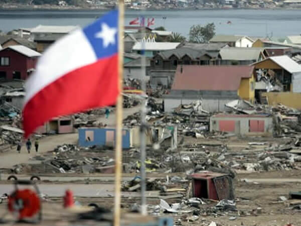
Roberto Benavente lists some key decisions made on the basis of incomplete knowledge. This is the case of the 27F Earthquake, where authorities were unable to act in a timely manner because they ignored the real extent of the impact of the earthquake and tsunami. Benavente affirms that “CIGIDEN is committed to permanently help improve the calculation methods to characterize earthquakes and tsunamis. This, because our territory is located in a seismogenic area, i.e., places where the largest earthquakes occur, and also because we understand that improving calculation bases for simulations during emergencies might mitigate the devastating consequences of these disasters”.

Anterior

Commemoration of the 1730 Valparaíso-Viña del Mar earthquake: Science, Remembrance and New Studies on Vertical Evacuation

Siguiente

28 years after the Antofagasta alluvium, new studies warn that there are still vulnerable territories

Siguiente
A 28 años del desastre por aluvión en Antofagasta nuevos estudios advierten que persisten territorios vulnerables

28 years after the Antofagasta alluvium, new studies warn that there are still vulnerable territories

  • Announcements
  • Contact
  • Idiomas

© 2025 JNews - Premium WordPress news & magazine theme by Jegtheme.

No hay resultado
Ver todos los resultados
  • NOSOTROS
    • El centro
    • Equipo
    • Investigadores
      • Investigadores
      • Personal de apoyo
      • Postdoctorados
    • Guía de Expertos 2020
  • INVESTIGACIÓN
    • Líneas de Investigación
      • L1. Amenazas por procesos de tierra sólida
      • L2. Amenazas por procesos de aguas superficiales
      • L3. Riesgo y resiliencia en sistemas complejos y redes
      • L4. Cultura del desastre y gobernanza del riesgo
      • L5. Evaluación socioeconómica para la mitigación del riesgo de infraestructura crítica
      • L6. Gobernanza Ciudadana
    • Proyectos
  • DIVULGACIÓN
    • Noticias
    • Cigiden en los medios
    • Columnas
    • Videos
    • Exposiciones
      • Chile territorio en movimiento
      • Desde el cielo
      • Desartes
  • PUBLICACIONES
    • Papers
    • Libros y manuales
    • Policy Papers
  • DESARTES
  • AGENDA
    • Seminarios y congresos
    • Conversatorios
    • Charlas y Talleres

© 2025 JNews - Premium WordPress news & magazine theme by Jegtheme.

Descarga el Informe II: Evento Incendios 02 y 03 de febrero de 2024, Viña del Mar (Región de Valparaíso)

    Descarga PP_Recuperación tras incendios en interfaz urbano-forestal

      Descarga el Policy Brief "Multi-risk analysis: What would happen if...?"

        Descarga el Informe de Daños: Evento Incendios 02 y 03 de febrero de 2024, Viña del Mar (Región de Valparaíso)

          Descarga el Informe post-desastre / Cuencas del Río Mataquito y Río Maule

            Descarga el Informe post-desastre / Cuenca del Río Maipo

              Descarga el Manual para la GRD Situada