Notice: Constant QUADMENU_DOMAIN already defined in /home/devicigi/cigidenweb.ing.uc.cl/wp-content/plugins/quadmenu/quadmenu.php on line 41

Notice: Accessing static property WPB_YourChannel::$yrc_permission as non static in /home/devicigi/cigidenweb.ing.uc.cl/wp-content/plugins/yourchannel/YourChannel.php on line 53
Scientists create a map that shows the impact of recent rains in the Metropolitan Región | CIGIDEN
  • Anuncios
  • Contacto
CIGIDEN
  • NOSOTROS
    • El centro
    • Equipo
    • Investigadores
      • Investigadores
      • Personal de apoyo
      • Postdoctorados
    • Guía de Expertos 2020
  • INVESTIGACIÓN
    • Líneas de Investigación
      • L1. Amenazas por procesos de tierra sólida
      • L2. Amenazas por procesos de aguas superficiales
      • L3. Riesgo y resiliencia en sistemas complejos y redes
      • L4. Cultura del desastre y gobernanza del riesgo
      • L5. Evaluación socioeconómica para la mitigación del riesgo de infraestructura crítica
      • L6. Gobernanza Ciudadana
    • Proyectos
  • DIVULGACIÓN
    • Noticias
    • Cigiden en los medios
    • Columnas
    • Videos
    • Exposiciones
      • Chile territorio en movimiento
      • Desde el cielo
      • Desartes
  • PUBLICACIONES
    • Papers
    • Libros y manuales
    • Policy Papers
  • DESARTES
  • AGENDA
    • Seminarios y congresos
    • Conversatorios
    • Charlas y Talleres
No hay resultado
Ver todos los resultados
CIGIDEN
No hay resultado
Ver todos los resultados
Inicio Dissemination

Scientists create a map that shows the impact of recent rains in the Metropolitan Región

The loss of the natural soil infiltration capacity and the absence of an efficient evacuating system for rainwater are also causing that help increase the impact of the last storm, which was classified as weak.

CIGIDEN Por CIGIDEN
22 enero, 2021
en Dissemination, L1. Solid earth processes and associated hazards, L2. Surface water processes and associated hazards, News
0
Scientists create a map that shows the impact of recent rains in the Metropolitan Región
0
Compartido
0
vistas
Share on FacebookShare on TwitterShare on Linkedin

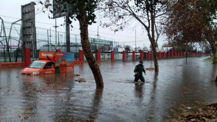
The rain on June 29th broke the extreme drought trend that the Metropolitan Region has been presenting over the last 12 years. A group of researchers from the Research Center for Integrated Disaster Risk Management, CIGIDEN by its initials in Spanish, carried out a data analysis of the impacts of the meteorological phenomenon that occurred last weekend, on June 28th and 29th. This event might reoccur today.

The data analysis and interpretation was conducted by academics and researchers José Saldías (CIGIDEN) and Jorge Gironas (CIGIDEN and academic of the Catholic University of Chile), along with the data collected by Gabriel González, CIGIDEN deputy director, and Felipe Aron, researcher of the same scientific center. This allowed CIGIDEN researchers Francisca Roldán and Erik Jensen to create a map that gathers the impacts on infrastructure caused by the last rains, i.e. multiple flooding spots, road defects and closures across Santiago, rockfalls and channel overflows.

According to the geologist and UCN academic, Gabriel Gonzalez, everything seems to indicates that it was a severe storm. However, «the analysis of data reveals the rain was not a heavy storm, but it is a matter of accumulated precipitation in Quinta Normal (according to the DMC record) of 36.3 mm -36 liters per square meter – with high intensity of 7 mm in 1 hour and a minor intensity 2 mm in 15 hours, which indicates that the storm resembles a rain with a return period of between 5 and 2 years».

Minor storm

The Urban Element Design Manual classifies this type of rain as a minor storm and stipulates that there should be no system collapse. «Then,» the researcher José Saldias says, «the multiple malfunctions observed show a design defect and reflect that the city is not able to withstand a severe storm, for instance, a rain with extended return periods. This is a wake-up call to improve Santiago’s resilience urgently.

Many floodings that may occur again with the rains forecasted for today are spatially related to channels. «The loss of the natural soil infiltration capacity and the absence of an efficient evacuating system for rainwater also contribute to the increased impact of this storm,» the geologist Felipe Aron affirms.

The map –which will soon be available on an interactive online platform– says the geologist Francisca Roldan, «allows us to visualize in a single space the impacts such as the activation of streams at foothills, floodings, river, and channel overflows, among others, on the Metropolitan Region. Identifying those vulnerable areas that should be strengthened for future events, «this map is a tool designed for disaster risk management,» says the researcher.

COMPLETE MAP IN HIGH RESOLUTION

https://cigidenweb.ing.uc.cl/2020/wp-content/uploads/2020/07/WhatsApp-Video-2020-07-05-at-21.51.14-1.mp4
Anterior

The generation of new tsunami risk areas due to an intentionally biased reconstruction process: Case study of llico after the 2010 Chile tsunami

Siguiente

Científicos crean mapa que reúne el impacto de las últimas lluvias en la Región Metropolitana

Siguiente
Científicos crean mapa que reúne el impacto de las últimas lluvias en la Región Metropolitana

Científicos crean mapa que reúne el impacto de las últimas lluvias en la Región Metropolitana

  • Announcements
  • Contact
  • Idiomas

© 2025 JNews - Premium WordPress news & magazine theme by Jegtheme.

No hay resultado
Ver todos los resultados
  • NOSOTROS
    • El centro
    • Equipo
    • Investigadores
      • Investigadores
      • Personal de apoyo
      • Postdoctorados
    • Guía de Expertos 2020
  • INVESTIGACIÓN
    • Líneas de Investigación
      • L1. Amenazas por procesos de tierra sólida
      • L2. Amenazas por procesos de aguas superficiales
      • L3. Riesgo y resiliencia en sistemas complejos y redes
      • L4. Cultura del desastre y gobernanza del riesgo
      • L5. Evaluación socioeconómica para la mitigación del riesgo de infraestructura crítica
      • L6. Gobernanza Ciudadana
    • Proyectos
  • DIVULGACIÓN
    • Noticias
    • Cigiden en los medios
    • Columnas
    • Videos
    • Exposiciones
      • Chile territorio en movimiento
      • Desde el cielo
      • Desartes
  • PUBLICACIONES
    • Papers
    • Libros y manuales
    • Policy Papers
  • DESARTES
  • AGENDA
    • Seminarios y congresos
    • Conversatorios
    • Charlas y Talleres

© 2025 JNews - Premium WordPress news & magazine theme by Jegtheme.

Descarga el Informe II: Evento Incendios 02 y 03 de febrero de 2024, Viña del Mar (Región de Valparaíso)

    Descarga PP_Recuperación tras incendios en interfaz urbano-forestal

      Descarga el Policy Brief "Multi-risk analysis: What would happen if...?"

        Descarga el Informe de Daños: Evento Incendios 02 y 03 de febrero de 2024, Viña del Mar (Región de Valparaíso)

          Descarga el Informe post-desastre / Cuencas del Río Mataquito y Río Maule

            Descarga el Informe post-desastre / Cuenca del Río Maipo

              Descarga el Manual para la GRD Situada