
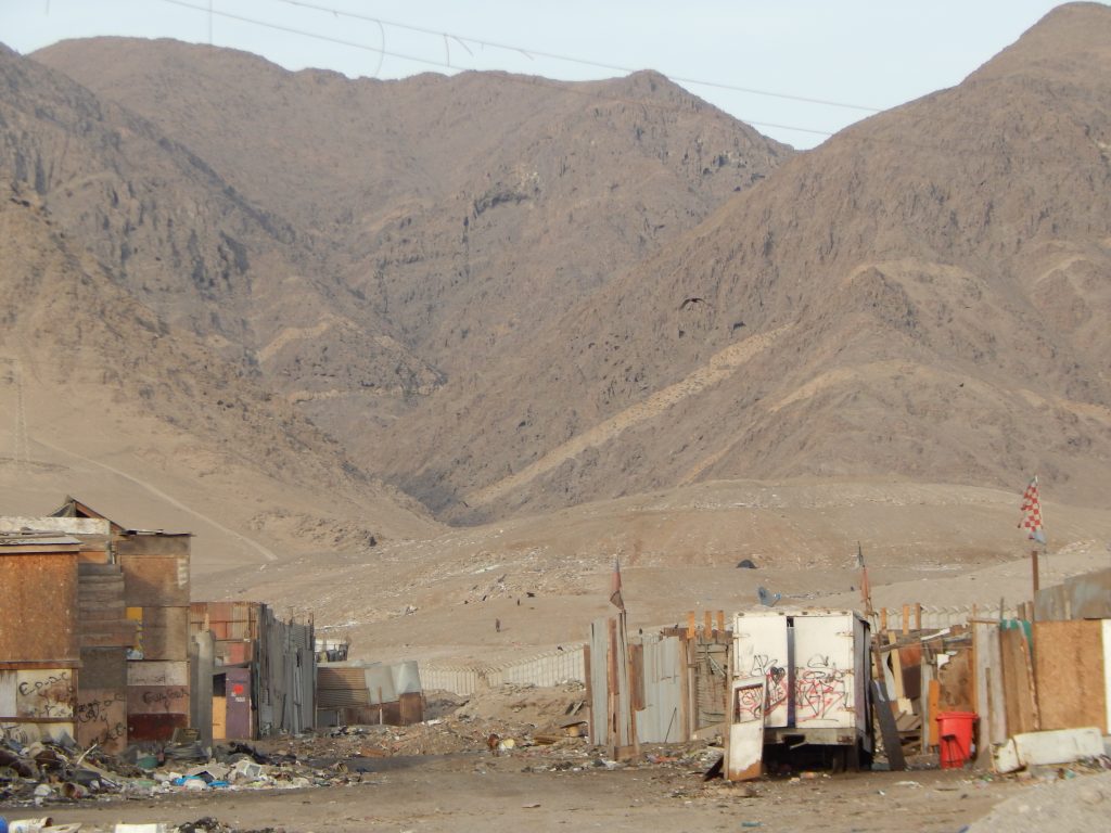
In spite of the major mitigation works carried out in Antofagasta after the catastrophe, there is still population at risk in the region, near streams such as La Chimba. If the 1991 meteorological phenomena recur, people could experience destructive alluvium.
Almost three decades ago, a climatic phenomenon of intense rains in the Antofagasta Region triggered one of the most violent disasters that northern Chile has experienced: several alluvia hit the cities of Antofagasta, Taltal and other smaller towns. During the early morning of June 18th, 1991, 17 and 42 mm of rain fell within 3 hours, considering that, on average, in one of the world’s driest deserts, the maximum daily rainfall does not exceed 2 millimeters.
Several factors contributed for alluviums to cause such a level of damage in the city of Antofagasta: “Unusual climatic characteristics for the north of the country, the city’s own geomorphology, the lack of mitigation works at the time and, finally, the characteristics of materials used in houses and territorial planning,” says Francisca Roldan, researcher at the Research Center for Integrated Disaster Risk Management, CIGIDEN, and geologist from the Universidad Católica del Norte.


Vulnerable population
On the other hand, Antofagasta has a significant number of hydrographic basins, all of which flow towards the west, the city’s urban zone. For this reason, in 1991, the greatest activation of streams concentrated in La Chimba, Farellones, Salar del Carmen, La Cadena, El Ancla, Baquedano, El Toro, La Negra, Jardines del Sur, Huáscar and El Way. The stream of Salar del Carmen and La Cadena caused the greater losses and damages to the population. In turn, most of these houses near the mouths of the basins are made of waste material, and thus, they have a low resistance to landslides or alluvia.
“During the events of June 18th, the activation of streams happened one hour after the rain began, with short concentration times and 15 a 30 km/h flows, with great destructive power. For this reason, flows caused major damages in several parts of the city, evidencing the lack of prior preparation for this type of natural events, namely, the absence of mitigation works, studies, preventive warnings or the lack of alluvial education for the population,” says Francisca Roldan.
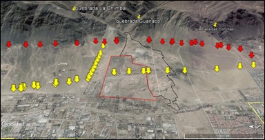

The study of La Chimba
The study found that an activation of the streams at La Chimba would lead to more vulnerable areas: The N/N unpaved street, located north of the Municipal Landfill, Los Topacios street, Huamachuco street, San Martín de Porres street, Pirita street, Sierra Nevada street, the central zone of the La Chimba Municipal Landfill, including Patricio Infante street and the eastern area of the area for extraction of aggregates. This includes urban and industrial areas and settlements of La Chimba, such as: La Quebrada, La Lucha es Posible, Luz Divina VI and a temporary neighborhood managed by priest Father Felipe Berrios.
According to Francisca Roldan, to quantify damages in urban areas in the event of alluviums, the movement of these flows must be analyzed on-site, in order to quantify and characterize the existing rocks or sediments, thus determining which areas are the most susceptible to this type of flows. Today, there are also new research tools, such as flood simulations with LIDAR images, which allow us to analyze other characteristics of the basins, including the type of soil in the streams, physical data such as slopes, areas and perimeters, among others (morphometric analysis) – and also to include hydro meteorological characterization, i.e., the study of meteorological phenomena (rainfall) direct related to hydrology (study of inland waters),” she explains.
According to the UCN geologist, La Chimba is at a high risk because most of the studies on landslides (alluviums) in Antofagasta are based on the 1991 alluvium, excluding this particular because it had few residents at the time. “On the other hand, the Municipal Landfill of La Chimba – with an area exceeding 700,000 m2 and more than 95 meters high – located in the middle of the river’s mouth and near urban areas, and a large area for extraction of aggregates of more than 800,000 m2, could increase the destructive power of potential alluvial flows,” explains Roldan.
Mitigation works


According to Francisca Roldan, decanting ponds have been found to be effective for many cases of rainfall, but thinking that they are capable of resisting any rainfall intensity levels and any contribution of sediments and anthropic material from the streams is a mistake. “Ideally, these mitigation measures should be supplemented with preventive warnings, with new studies to get the basin response time, and anthropogenic materials in the city and the areas of extraction of aggregates should be controlled and reduced. We need alluvial education campaigns, to disseminate hazard maps and to have a better prepared population, not only in Antofagasta, but throughout the country,” she concludes.